If you’re a visual learner like most information-hungry Internet users, then you’ll know that maps, graphs, and infographics really do help you interpret data and information in a much easier and more ingenious way. Maps can make a point resonance with readers and this collection of illustrations and aims and allows you to do exactly that.

The fact is that maps can be a very powerful tool for understanding the world and how it works. So when I saw a post on Reddit titled “Maps That Don’t Teach in School,” I immediately thought I should share it. Some of them are too nerdy or deal directly with data references just for the US, but they are still fascinating and easily understandable.
Hopefully some of these maps will cause surprises and help you learn something new. Some are important for knowledge, others are simply valuable for their creative way of displaying data. See for yourself!
1. Places where Google Street View is available

2. Countries that do not use the metric system

3. The Only 22 Countries Britain Didn’t Invade

4. Map of “Pangaea” with current international borders

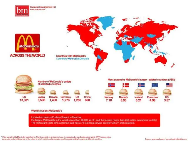
5. McDonald’s Worldwide

6. Paid Motherhood Worldwide

7. The most common surnames in Europe by country.

8. Car Driving Guidance by Country

9. Antarctica Time Zone Map

10. Overall Internet Usage Based on Time Elapsed in a Day

11. The World’s Busiest Air Routes in 2012

12. Visualization of local population density

13. Map of the Flags of the World

14. Map of Alcohol Consumption Around the World

15. Ranking Popularity of Alcoholic Beverages by Country

16. Map of adjacent rivers in the United States

17. Map of the Highest Paid Professionals by State in the U.S.

18. Map of the world with earthquakes since 1898

19. Route map of 29,000 rubber duckies after falling from a cargo ship in the middle of the Pacific Ocean

20. Map of the countries with the most bribes

21. Map of the World of Vegetation on Earth

22. The average age of first sexual intercourse by country

23. If the world’s population lived in a city

24. The number of researchers per million inhabitants

25. World Map of Oil Import and Export Flows

26. The 7,000 Rivers That Feed the Mississippi River

27. World Map of Writing Systems

28. Global Coffee Consumption Per Capita Annually

29. The economic center of gravity since 1 A.D.

30. The world divided into seven regions, each with a population of one billion

31. Earth’s Population by Latitude and Longitude

32. Map of the United States Overlaid on the Moon

33. Lightning Frequency Around the World

34. Global Water Risk in the World

35. The World’s Most Dangerous Areas for Commercial Shipping Due to Pirates

36. The Area Codes in Which Ludacris Says There Are More Women Than the Easy Life

37. An area home to only 2% of Australia’s population

38. The longest straight you can navigate on Earth (Pakistan to Kamchatka Peninsula, Russia – 20,000 miles)

39. Map of Europe showing literal Chinese translations of country names

40. Reverse map with the Southern Hemisphere at the top of the map (due to the position of the North being arbitrary)

